PART 224 - ENDANGERED MARINE AND ANADROMOUS SPECIES
Source:
64 FR 14066, Mar. 23, 1999, unless otherwise noted.
§ 224.101 Enumeration of endangered marine and anadromous species.
(a) The regulations in this part identify the species under the jurisdiction of the Secretary of Commerce that have been determined to be endangered species pursuant to section 4(a) of the Act, and provide for the conservation of such species by establishing rules and procedures to governing activities involving the species.
(b) The regulations in this part apply only to the endangered species enumerated in this section.
(c) The provisions of this part are in addition to, and not in lieu of, other regulations of parts 222 through 226 of this chapter which prescribe additional restrictions or conditions governing endangered species.
(d) The table below identifies the species under the jurisdiction of the Secretary of Commerce that have been determined to be endangered pursuant to section 4(a) of the Act, species treated as endangered because they are sufficiently similar in appearance to endangered species, and experimental populations of endangered species.
(e) The columns entitled “Common name,” “Scientific name,” and “Description of listed entity” define the species within the meaning of the Act. In the “Common name” column, experimental populations are identified as “XE” for essential populations or “XN” for nonessential populations. Species listed based on similarity of appearance are identified as “S/A.” Although a column for “Common name” is included, common names cannot be relied upon for identification of any specimen, because they may vary greatly in local usage. The “Scientific name” column provides the most recently accepted scientific name, relying to the extent practicable on the International Code of Zoological Nomenclature. In cases in which confusion might arise, a synonym(s) will be provided in parentheses. The “Description of listed entity” column identifies whether the listed entity comprises the entire species, a subspecies, or a distinct population segment (DPS) and provides a description for any DPSs. Unless otherwise indicated in the “Description of listed entity” column, all individual members of the listed entity and their progeny retain their listing status wherever found, including individuals in captivity. Information regarding the general range of the species, subspecies, or DPS may be found in the Federal Register notice(s) cited in the “Citation(s) for listing determination(s)” column.
(f) The “Citation(s) for listing determination(s)” column provides reference to the Federal Register notice(s) determining the species' status under the Act. The abbreviation “(SPR)” (significant portion of its range) after a citation indicates that the species was listed based on its status in a significant portion of its range. If a citation does not include the “(SPR)” notation, it means that the species was listed based on its status throughout its entire range. For “(SPR)” listings, a geographical description of the SPR may be found in the referenced Federal Register Notice. The “(SPR)” notation serves an informational purpose only and does not imply any limitation on the application of the prohibitions or restrictions of the Act or implementing rules.
(g) The “Critical habitat” and “ESA rules” columns provide cross-references to other sections in this part and part 226. The term “NA” appearing in the “Critical habitat” column indicates that there are no critical habitat designations for that species; similarly, the term “NA” appearing in the “ESA rules” column indicates that there are no ESA rules for that species. However, all other applicable rules in parts 222 through 226 and part 402 still apply to that species. Also, there may be other rules in this title that relate to such wildlife. The “ESA rules” column is not intended to list all Federal, state, tribal, or local governmental regulations that may apply to the species.
(h) The endangered species under the jurisdiction of the Secretary of Commerce are:
| Species1 | Citation(s) for listing
determination(s) |
Critical
habitat |
ESA rules | ||
|---|---|---|---|---|---|
| Common name | Scientific name | Description of listed entity | |||
| Marine Mammals | |||||
| Dolphin, Chinese River (aka baiji) | Lipotes vexillifer | Entire species | 54 FR 22906, May 30, 1989 | NA | NA. |
| Dolphin, Maui | Cephalorhynchus hectori maui | Entire subspecies | 82 FR 43701, September 19, 2017 | NA | NA |
| Dolphin, South Asian River (Indus River subspecies) | Platanista gangetica minor | Entire subspecies | 55 FR 50835, Dec. 11, 1990 | NA | NA. |
| Dolphin, Taiwanese humpback | Sousa chinensis taiwanensis | Entire subspecies | 83 FR 21182, May 9, 2018 | NA | NA |
| Porpoise, Gulf of California harbor (aka vaquita or cochito) | Phocoena sinus | Entire species | 50 FR 1056, Jan. 9, 1985 | NA | NA. |
| Sea lion, Steller (Western DPS) | Eumetopias jubatus | Steller sea lions born in the wild, west of 144° W. Long. Also, Steller sea lions born in captivity whose mother was born in the wild, west of 144° W. Long., and progeny of these captives | 62 FR 24345, May 5, 1997 | 226.202 | 224.103, 226.202. |
| Seal, Hawaiian monk | Neomonachus schauinslandi (= Monachus schauinslandi) | Entire Species | 41 FR 51611, Nov. 23, 1976 | 226.201 | NA. |
| Seal, Mediterranean monk | Monachus monachus | Entire species | 35 FR 8491, June 2, 1970 | NA | NA. |
| Seal, ringed (Ladoga subspecies) | Phoca (=Pusa) hispida ladogensis | Entire subspecies | 77 FR 76706; Dec. 28, 2012 | NA | NA. |
| Seal, ringed (Saimaa subspecies) | Phoca (=Pusa) hispida saimensis | Entire subspecies | 58 FR 26920, May 6, 1993 | NA | NA. |
| Whale, beluga (Cook Inlet DPS) | Delphinapterus leucas | Beluga whales originating from Cook Inlet, Alaska | 73 FR 62919, Oct. 22, 2008 | 226.220 | NA. |
| Whale, blue | Balaenoptera musculus | Entire species | 35 FR 18319, Dec. 2, 1970 | NA | NA. |
| Whale, bowhead | Balaena mysticetus | Entire species | 35 FR 18319, Dec. 2, 1970 | NA | NA. |
| Whale, Bryde's (Gulf of Mexico subspecies) | Balaenoptera edeni (unnamed subspecies) | Bryde's whales that breed and feed in the Gulf of Mexico | 84 FR 15446, April 15, 2019 | NA | NA |
| Whale, false killer (Main Hawaiian Islands Insular DPS) | Pseudorca crassidens | False killer whales found from nearshore of the main Hawaiian Islands out to 140 km (approximately 75 nautical miles) and that permanently reside within this geographic range | 77 FR 70915, Nov. 28, 2012 | § 226.226 | NA. |
| Whale, fin or finback | Balaenoptera physalus | Entire species | 35 FR 8491, June 2, 1970 | NA | NA. |
| Whale, gray (Western North Pacific DPS) | Eschrichtius robustus | Western North Pacific (Korean) gray whales | 35 FR 8491, June 2, 1970; 59 FR 31094, June 16, 1994 | NA | NA. |
| Whale, humpback (Arabian Sea DPS) | Megaptera novaeangliae | Humpback whales that breed and feed in the Arabian Sea | 81 FR 62260, Sept. 8, 2016 | NA | NA. |
| Whale, humpback (Cape Verde Islands/Northwest Africa DPS) | Megaptera novaeangliae | Humpback whales that breed in waters surrounding the Cape Verde Islands in the Eastern North Atlantic Ocean, as well as those that breed in an undetermined breeding area in the eastern tropical Atlantic (possibly Canary Current) and feed along the Iceland Shelf and Sea and the Norwegian Sea | 81 FR 62260, Sept. 8, 2016 | NA | NA. |
| Whale, humpback (Central America DPS) | Megaptera novaeangliae | Humpback whales that breed in waters off Central America in the North Pacific Ocean and feed along the West Coast of the United States and southern British Columbia | 81 FR 62260, Sept. 8, 2016 | 226.227 | |
| Whale, humpback (Western North Pacific DPS) | Megaptera novaeangliae | Humpback whales that breed or winter in the area of Okinawa and the Philippines in the Kuroshio Current (as well as unknown breeding grounds in the Western North Pacific Ocean), transit the Ogasawara area, or feed in the North Pacific Ocean, primarily in the West Bering Sea and off the Russian coast and the Aleutian Islands | 81 FR 62260, Sept. 8, 2016 | 226.227 | |
| Whale, killer (Southern Resident DPS) | Orcinus orca | Killer whales from the J, K, and L pods | 80 FR 7380, Feb. 10, 2015 | 226.206 | 224.103. |
| Whale, North Atlantic right | Eubalaena glacialis | Entire species | 73 FR 12024, Mar. 6, 2008 | 226.203 | 224.103, 224.105. |
| Whale, North Pacific right | Eubalaena japonica | Entire species | 73 FR 12024, Mar. 6, 2008 | 226.215 | 224.103. |
| Whale, sei | Balaenoptera borealis | Entire species | 35 FR 18319, Dec. 2, 1970 | NA | NA. |
| Whale, Southern right | Eubalaena australis | Entire species | 35 FR 18319, Dec. 2, 1970 | NA | NA. |
| Whale, sperm | Physeter macrocephalus (= catodon) | Entire species | 35 FR 18319, Dec. 2, 1970 | NA | NA. |
| Reptiles2 | |||||
| Sea snake, dusky | Aipysurus fuscus | Entire species | 80 FR 60560, Oct. 7, 2015 | NA | NA. |
| Sea turtle, green (Central South Pacific DPS) | Chelonia mydas | Green sea turtles originating from the Central South Pacific Ocean, bounded by the following coordinates: 9° N., 175° W. in the northwest; 9° N., 125° W. in the northeast; 40° S., 96° W. in the southeast; 40° S., 176° E. in the southwest; and 13° S., 171° E. in the west | 81 FR 20058, Apr. 6, 2016 | NA | 224.104. |
| Sea turtle, green (Central West Pacific DPS) | Chelonia mydas | Green sea turtles originating from the Central West Pacific Ocean, bounded by the following coordinates: 41° N., 146° E. in the northwest; 41° N., 169° E. in the northeast; 9° N., 175° W. in the east; 13° S., 171° E. in the southeast; along the northern coast of the island of New Guinea; and 4.5° N., 129° E. in the west | 81 FR 20058, Apr. 6, 2016 | NA | 224.104. |
| Sea turtle, green (Mediterranean DPS) | Chelonia mydas | Green sea turtles originating from the Mediterranean Sea, bounded by 5.5° W. Long. in the west | 81 FR 20058, Apr. 6, 2016 | NA | 224.104. |
| Sea turtle, hawksbill | Eretmochelys imbricata | Entire species | 35 FR 8491, June 2, 1970 | 226.209 | 224.104. |
| Sea turtle, Kemp's ridley | Lepidochelys kempii | Entire species | 35 FR 18319, Dec. 2, 1970 | NA | 224.104. |
| Sea turtle, leatherback | Dermochelys coriacea | Entire species | 35 FR 8491, June 2, 1970 | 226.207 | 224.104. |
| Sea turtle, loggerhead (Mediterranean Sea DPS) | Caretta caretta | Loggerhead sea turtles originating from the Mediterranean Sea east of 5°36′ W. Long | 76 FR 58868, Sept. 22, 2011 | NA | 224.104. |
| Sea turtle, loggerhead (North Indian Ocean DPS) | Caretta caretta | Loggerhead sea turtles originating from the North Indian Ocean north of the equator and south of 30° N. Lat | 76 FR 58868, Sept. 22, 2011 | NA | 224.104. |
| Sea turtle, loggerhead (North Pacific Ocean DPS) | Caretta caretta | Loggerhead sea turtles originating from the North Pacific north of the equator and south of 60° N. Lat | 76 FR 58868, Sept. 22, 2011 | NA | 224.104. |
| Sea turtle, loggerhead (Northeast Atlantic Ocean DPS) | Caretta caretta | Loggerhead sea turtles originating from the Northeast Atlantic Ocean north of the equator, south of 60° N. Lat., and east of 40° W. Long., except in the vicinity of the Strait of Gibraltar where the eastern boundary is 5°36′ W. Long | 76 FR 58868, Sept. 22, 2011 | NA | 224.104. |
| Sea turtle, loggerhead (South Pacific Ocean DPS) | Caretta caretta | Loggerhead sea turtles originating from the South Pacific south of the equator, north of 60° S. Lat., west of 67° W. Long., and east of 141° E. Long | 76 FR 58868, Sept. 22, 2011 | NA | 224.104. |
| Sea turtle, olive ridley | Lepidochelys olivacea | Breeding colony populations on the Pacific coast of Mexico | 43 FR 32800, July 28, 1978 | NA | 224.104. |
| Fishes | |||||
| Angelshark, common | Squatina squatina | Entire species | 81 FR 50394, Aug. 1, 2016 | NA | NA. |
| Angelshark, Argentine | Squatina argentina | Entire species | 82 FR 21722, May 10, 2017 | NA | NA |
| Angelshark, sawback | Squatina aculeata | Entire species | 81 FR 50394, Aug. 1, 2016 | NA | NA. |
| Angelshark, smoothback | Squatina oculata | Entire species | 81 FR 50394, Aug. 1, 2016 | NA | NA. |
| Angelshark, spiny | Squatina guggenheim | Entire species | 82 FR 21722, May 10, 2017 | NA | NA |
| Bocaccio (Puget Sound/Georgia Basin DPS) | Sebastes paucispinis | Bocaccio residing within the Puget Sound/Georgia Basin to the Northern Boundary of the Northern Strait of Georgia along the southern contours of Quadra Island, Maurelle Island and Sonora Island, all of Bute Inlet The Western Boundary of the U.S. side in the Strait of Juan de Fuca is N 48 7′16″, W123 17′15″ in a straight line to the Canadian side at N 48 24′40″, 123 17′38″ | 75 FR 22276, Apr. 28, 2010 | 226.224 | NA. |
| Grouper, gulf | Mycteroperca jordani | Entire species | 81 FR 72545, Oct. 20, 2016 | NA | NA. |
| Guitarfish, Brazilian | Rhinobatos horkelii | Entire species | 82 FR 21722, May 10, 2017 | NA | NA |
| Salmon, Atlantic (Gulf of Maine DPS) | Salmo salar | Naturally spawned Atlantic salmon originating from the Gulf of Maine, including such Atlantic salmon originating from watersheds from the Androscoggin River northward along the Maine coast to the Dennys River. Also, Atlantic salmon from two artificial propagation programs: Green Lake National Fish Hatchery (GLNFH) and Craig Brook National Fish Hatchery (CBNFH). This DPS does not include landlocked salmon and those salmon raised in commercial hatcheries for aquaculture | 74 FR 29344, June 19, 2009 | 226.217 | NA. |
| Salmon, Chinook (Sacramento River winter-run ESU) | Oncorhynchus tshawytscha | Naturally spawned winter-run Chinook salmon originating from the Sacramento River and its tributaries. Also, winter-run Chinook salmon from the following artificial propagation programs: The Livingston Stone National Fish Hatchery (Supplementation and Captive Broodstock) | 70 FR 37160, June 28, 2005 | 226.204 | NA |
| Salmon, Chinook (Upper Columbia River spring-run ESU) | Oncorhynchus tshawytscha | Naturally spawned spring-run Chinook salmon originating from Columbia River tributaries upstream of the Rock Island Dam and downstream of Chief Joseph Dam (excluding the Okanogan River subbasin). Also, spring-run Chinook salmon from the following artificial propagation programs: The Twisp River Program; Chief Joseph spring Chinook Hatchery Program (Okanogan release); Methow Program; Winthrop National Fish Hatchery Program; Chiwawa River Program; White River Program; and the Nason Creek Program | 70 FR 37160, June 28, 2005 | 226.212 | NA |
| Salmon, coho (Central California Coast ESU) | Oncorhynchus kisutch | Naturally spawned coho salmon originating from rivers south of Punta Gorda, California to and including Aptos Creek, as well as such coho salmon originating from tributaries to San Francisco Bay. Also, coho salmon from the following artificial propagation programs: The Don Clausen Fish Hatchery Captive Broodstock Program; the Scott Creek/King Fisher Flats Conservation Program; and the Scott Creek Captive Broodstock Program | 70 FR 37160, June 28, 2005; 77 FR 19552, Apr. 2, 2012 | 226.210 | NA |
| Salmon, sockeye (Snake River ESU) | Oncorhynchus nerka | Naturally spawned anadromous and residual sockeye salmon originating from the Snake River basin. Also, sockeye salmon from the Redfish Lake Captive Broodstock Program and the Snake River Sockeye Salmon Hatchery Program | 70 FR 37160, June 28, 2005 | 226.205 | NA |
| Sawfish, dwarf | Pristis clavata | Entire species | 79 FR 73978, Dec. 12, 2014 | NA | NA. |
| Sawfish, green | Pristis zijsron | Entire species | 79 FR 73978, Dec. 12, 2014 | NA | NA. |
| Sawfish, largetooth | Pristis pristis (formerly Pristis perotteti, Pristis pristis, and Pristis microdon) | Entire species | 79 FR 73978, Dec. 12, 2014 | NA | NA. |
| Sawfish, narrow | Anoxypristis cuspidata | Entire species | 79 FR 73978, Dec. 12, 2014 | NA | NA. |
| Sawfish, smalltooth (United States DPS) | Pristis pectinata | Smalltooth sawfish originating from U.S. waters | 68 FR 15674, Apr. 1, 2003 | 226.218 | NA. |
| Sawfish, smalltooth (Non-U.S. DPS) | Pristis pectinata | Smalltooth sawfish originating from non-U.S. waters | 79 FR 73978, Dec. 12, 2014 | NA | NA. |
| Shark, daggernose | Isogomphodon oxyrhynchus | Entire species | 82 FR 21722, May 10, 2017 | NA | NA |
| Shark, scalloped hammerhead (Eastern Atlantic DPS) | Sphyrna lewini | Scalloped hammerhead sharks originating from the Eastern Atlantic Ocean, including all waters of the Mediterranean Sea, and delineated by the following boundary lines: bounded to the west by 30° W. long., to the north by 40° N. lat., to the south by 36° S. lat., and to the east by 20° E. long | 79 FR 38214, July 3, 2014 | NA | NA. |
| Shark, scalloped hammerhead (Eastern Pacific DPS) | Sphyrna lewini | Scalloped hammerhead sharks originating from the Eastern Pacific Ocean, delineated by the following boundary lines: bounded to the north by 40° N lat. and to the south by 36° S lat. The western boundary line extends from 140° W. long. due south to 10° N., then due west along 10° N. lat. to 150° W. long., then due south to 4° S. lat., then due east along 4° S. lat. to 130° W. long, and then extends due south along 130° W. long | 79 FR 38214, July 3, 2014 | NA | NA. |
| Shark, striped smoothhound | Mustelus fasciatus | Entire species | 82 FR 21722, May 10, 2017 | NA | NA |
| Steelhead (Southern California DPS) | Oncorhynchus mykiss | Naturally spawned anadromous O. mykiss (steelhead) originating below natural and manmade impassable barriers from the Santa Maria River to the U.S.-Mexico Border | 71 FR 834, Jan. 5, 2006 | 226.211 | NA. |
| Sturgeon, Adriatic | Acipenser naccarii | Entire species | 79 FR 31222, June 2, 2014 | NA | NA. |
| Sturgeon, Atlantic (Atlantic subspecies; Carolina DPS) | Acipenser oxyrinchus oxyrinchus | Atlantic sturgeon originating from watersheds (including all rivers and tributaries) from Albemarle Sound southward along the southern Virginia, North Carolina, and South Carolina coastal areas to Charleston Harbor | 77 FR 5914, Feb. 6, 2012 | NA | NA. |
| Sturgeon, Atlantic (Atlantic subspecies; Chesapeake Bay DPS) | Acipenser oxyrinchus oxyrinchus | Anadromous Atlantic sturgeon originating from watersheds that drain into the Chesapeake Bay and into coastal waters from the Delaware-Maryland border on Fenwick Island to Cape Henry, Virginia | 77 FR 5880, Feb. 6, 2012 | NA | NA. |
| Sturgeon, Atlantic (Atlantic subspecies; New York Bight DPS) | Acipenser oxyrinchus oxyrinchus | Anadromous Atlantic sturgeon originating from watersheds that drain into coastal waters, including Long Island Sound, the New York Bight, and Delaware Bay, from Chatham, Massachusetts to the Delaware-Maryland border on Fenwick Island | 77 FR 5880, Feb. 6, 2012 | NA | NA. |
| Sturgeon, Atlantic (Atlantic subspecies; South Atlantic DPS) | Acipenser oxyrinchus oxyrinchus | Atlantic sturgeon originating from watersheds (including all rivers and tributaries) of the ACE (Ashepoo, Combahee, and Edisto) Basin southward along the South Carolina, Georgia, and Florida coastal areas to the St. Johns River, Florida | 77 FR 5914, Feb. 6, 2012 | NA | NA. |
| Sturgeon, Chinese | Acipenser sinensis | Entire species | 79 FR 31222, June 2, 2014 | NA | NA. |
| Sturgeon, European | Acipenser sturio | Entire species | 79 FR 31222, June 2, 2014 | NA | NA. |
| Sturgeon, Kaluga | Huso dauricus | Entire species | 79 FR 31222, June 2, 2014 | NA | NA. |
| Sturgeon, Sakhalin | Acipenser mikadoi | Entire species | 79 FR 31222, June 2, 2014 | NA | NA. |
| Sturgeon, shortnose | Acipenser brevirostrum | Entire species | 32 FR 4001, Mar. 11, 1967 | NA | NA. |
| Totoaba | Cynoscion macdonaldi | Entire species | 44 FR 29480, May 21, 1979 | NA | NA. |
| Molluscs | |||||
| Abalone, black | Haliotis cracherodii | Entire species | 74 FR 1937, Jan. 14, 2009 | 226.221 | NA. |
| Abalone, white | Haliotis sorenseni | Entire species | 66 FR 29054, May 29, 2001 | NA | NA. |
| Corals | |||||
| Coral, [no common name] | Cantharellus noumeae | Entire species | 80 FR 60560, Oct. 7, 2015 | NA | NA. |
| Coral, [no common name] | Siderastrea glynni | Entire species | 80 FR 60560, Oct. 7, 2015 | NA | NA. |
| Coral, [no common name] | Tubastraea floreana | Entire species | 80 FR 60560, Oct. 7, 2015 | NA | NA. |
[79 FR 20814, Apr. 14, 2014, as amended at 79 FR 31227, June 2, 2014; 79 FR 38241, July 3, 2014; 79 FR 68372, Nov. 17, 2014; 79 FR 74005, Dec. 12, 2014; 79 FR 78725, Dec. 31, 2014; 80 FR 7978, Feb. 13, 2015; 80 FR 7390, Feb. 10, 2015; 80 FR 60564, Oct. 7, 2015; 81 FR 20090, Apr. 6, 2016; 81 FR 50400, Aug. 1, 2016; 81 FR 62320, Sept. 8, 2016; 81 FR 72549, Oct. 20, 2016; 82 FR 7720, Jan. 23, 2017; 82 FR 21740, May 10, 2017; 82 FR 43710, Septt. 19, 2017; 83 FR 21186, May 9, 2018; 83 FR 35091, July 24, 2018]; 84 FR 15487, Apr. 15, 2019; 85 FR 81836, Dec. 17, 2020; 86 FR 21152, Apr. 21, 2021
§ 224.102 Permits for endangered marine and anadromous species.
No person shall take, import, export, or engage in any activity prohibited by section 9 of the Act involving any marine species that has been determined to be endangered under the Endangered Species Conservation Act of 1969 or the Act, and that is under the jurisdiction of the Secretary, without a valid permit issued pursuant to part 222, subpart C of this chapter.
§ 224.103 Special prohibitions for endangered marine mammals.
(a) [Reserved]
(b) Approaching endangered humpback whales in Alaska —
(1) Prohibitions. Except as provided under paragraph (b)(2) of this section, it is unlawful for any person subject to the jurisdiction of the United States to commit, to attempt to commit, to solicit another to commit, or to cause to be committed, within 200 nautical miles (370.4 km) of Alaska, or within inland waters of the state, any of the acts in paragraphs (b)(1)(i) through (b)(1)(iii) of this section with respect to endangered humpback whales (Megaptera novaeangliae):
(i) Approach, by any means, including by interception (i.e., placing a vessel in the path of an oncoming humpback whale so that the whale surfaces within 100 yards (91.4 m) of the vessel), within 100 yards (91.4 m) of any humpback whale;
(ii) Cause a vessel or other object to approach within 100 yards (91.4 m) of a humpback whale; or
(iii) Disrupt the normal behavior or prior activity of a whale by any other act or omission. A disruption of normal behavior may be manifested by, among other actions on the part of the whale, a rapid change in direction or speed; escape tactics such as prolonged diving, underwater course changes, underwater exhalation, or evasive swimming patterns; interruptions of breeding, nursing, or resting activities, attempts by a whale to shield a calf from a vessel or human observer by tail swishing or by other protective movement; or the abandonment of a previously frequented area.
(2) Exceptions. The following exceptions apply to this paragraph (b), but any person who claims the applicability of an exception has the burden of proving that the exception applies:
(i) Paragraph (b)(1) of this section does not apply if an approach is authorized by the National Marine Fisheries Service through a permit issued under part 222, subpart C, of this chapter (General Permit Procedures) or through a similar authorization.
(ii) Paragraph (b)(1) of this section does not apply to the extent that a vessel is restricted in its ability to maneuver and, because of the restriction, cannot comply with paragraph (b)(1) of this section.
(iii) Paragraph (b)(1) of this section does not apply to commercial fishing vessels lawfully engaged in actively setting, retrieving or closely tending commercial fishing gear. For purposes of this paragraph (b), commercial fishing means taking or harvesting fish or fishery resources to sell, barter, or trade. Commercial fishing does not include commercial passenger fishing operations (i.e. charter operations or sport fishing activities).
(iv) Paragraph (b)(1) of this section does not apply to state, local, or Federal government vessels operating in the course of official duty.
(v) Paragraph (b)(1) of this section does not affect the rights of Alaska Natives under 16 U.S.C. 1539(e).
(vi) Paragraph (b) of this section shall not take precedence over any more restrictive conflicting Federal regulation pertaining to humpback whales, including the regulations at 36 CFR 13.1102-13.1188 that pertain specifically to the waters of Glacier Bay National Park and Preserve.
(3) General measures. Notwithstanding the prohibitions and exceptions in paragraphs (b)(1) and (2) of this section, to avoid collisions with endangered humpback whales, vessels must operate at a slow, safe speed when near a humpback whale. “Safe speed” has the same meaning as the term is defined in 33 CFR 83.06 and the International Regulations for Preventing Collisions at Sea 1972 (see 33 U.S.C. 1602) with respect to avoiding collisions with humpback whales.
(c) Approaching right whales —
(1) Prohibitions. Except as provided under paragraph (c)(3) of this section, it is unlawful for any person subject to the jurisdiction of the United States to commit, attempt to commit, to solicit another to commit, or cause to be committed any of the following acts:
(i) Approach (including by interception) within 500 yards (460 m) of a right whale by vessel, aircraft, or any other means;
(ii) Fail to undertake required right whale avoidance measures specified under paragraph (c)(2) of this section.
(2) Right whale avoidance measures. Except as provided under paragraph (c)(3) of this section, the following avoidance measures must be taken if within 500 yards (460 m) of a right whale:
(i) If underway, a vessel must steer a course away from the right whale and immediately leave the area at a slow safe speed.
(ii) An aircraft must take a course away from the right whale and immediately leave the area at a constant airspeed.
(3) Exceptions. The following exceptions apply to this section, but any person who claims the applicability of an exception has the burden of proving that the exception applies:
(i) Paragraphs (c)(1) and (c)(2) of this section do not apply if a right whale approach is authorized by the National Marine Fisheries Service through a permit issued under part 222, subpart C, of this chapter (General Permit Procedures) or through a similar authorization.
(ii) Paragraphs (c)(1) and (c)(2) of this section do not apply where compliance would create an imminent and serious threat to a person, vessel, or aircraft.
(iii) Paragraphs (c)(1) and (c)(2) of this section do not apply when approaching to investigate a right whale entanglement or injury, or to assist in the disentanglement or rescue of a right whale, provided that permission is received from the National Marine Fisheries Service or designee prior to the approach.
(iv) Paragraphs (c)(1) and (c)(2) of this section do not apply to an aircraft unless the aircraft is conducting whale watch activities.
(v) Paragraph (c)(2) of this section does not apply to the extent that a vessel is restricted in her ability to maneuver and, because of the restriction, cannot comply with paragraph (c)(2) of this section.
(d) Special prohibitions relating to endangered Steller sea lion protection —
(1) General Prohibitions. The following regulatory provisions shall apply to the western population of Steller sea lions:
(i) No discharge of firearms. Except as provided in paragraph (d)(2) of this section, no person subject to the jurisdiction of the United States may discharge a firearm at or within 100 yards (91.4 meters) of a Steller sea lion west of 144 °W longitude. A firearm is any weapon, such as a pistol or rifle, capable of firing a missile using an explosive charge as a propellant.
(ii) No approach in buffer areas. Except as provided in paragraph (d)(2) of this section:
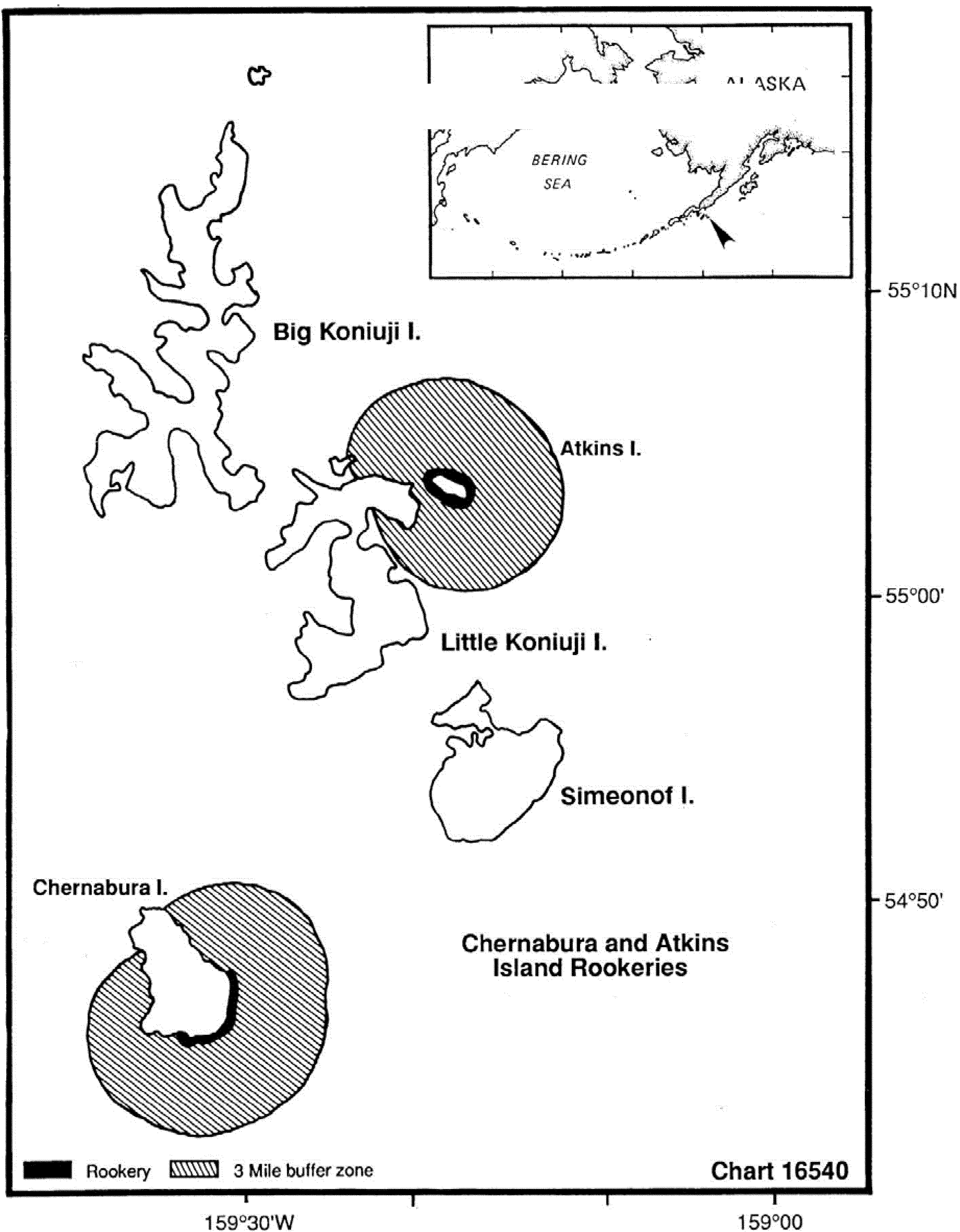
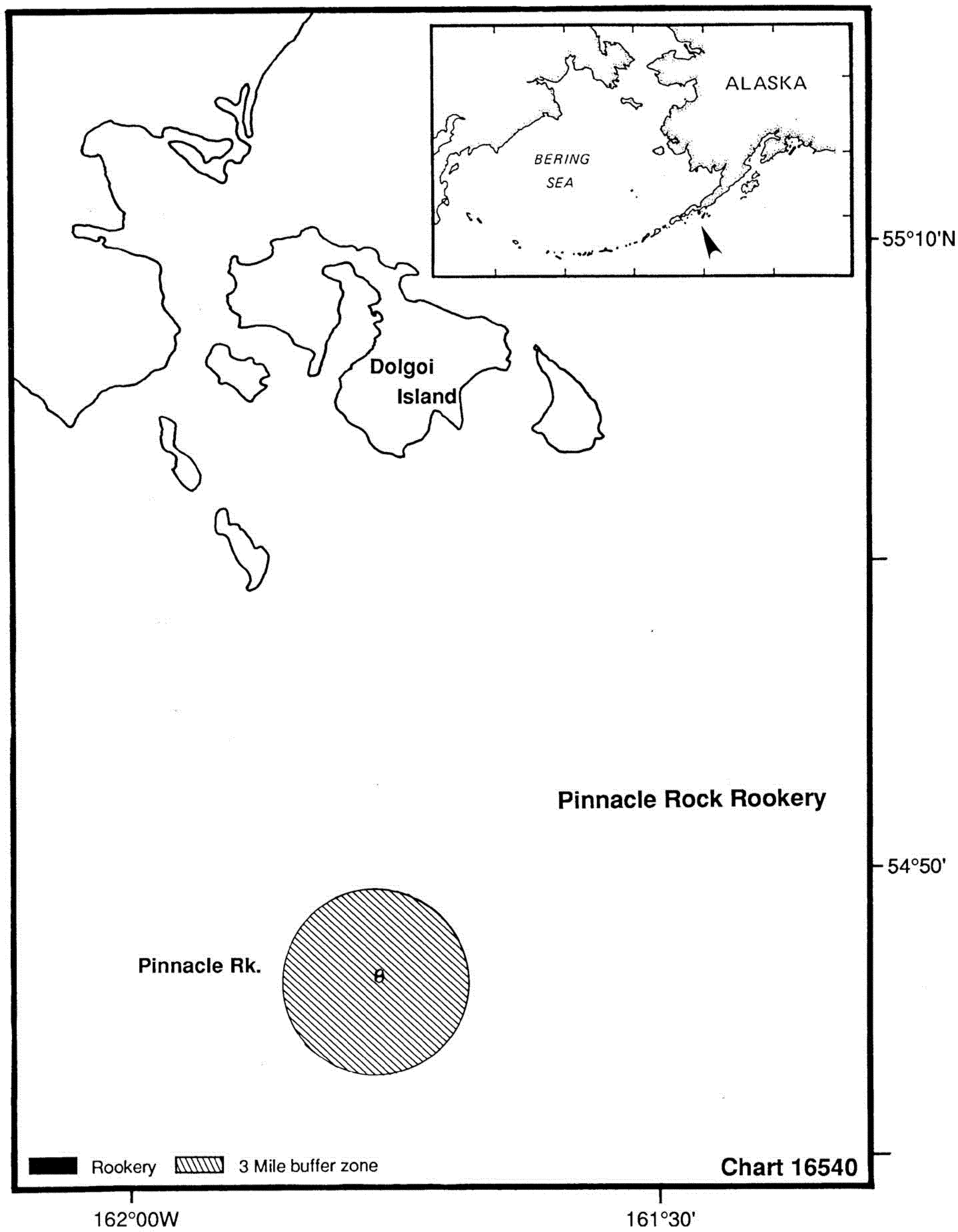
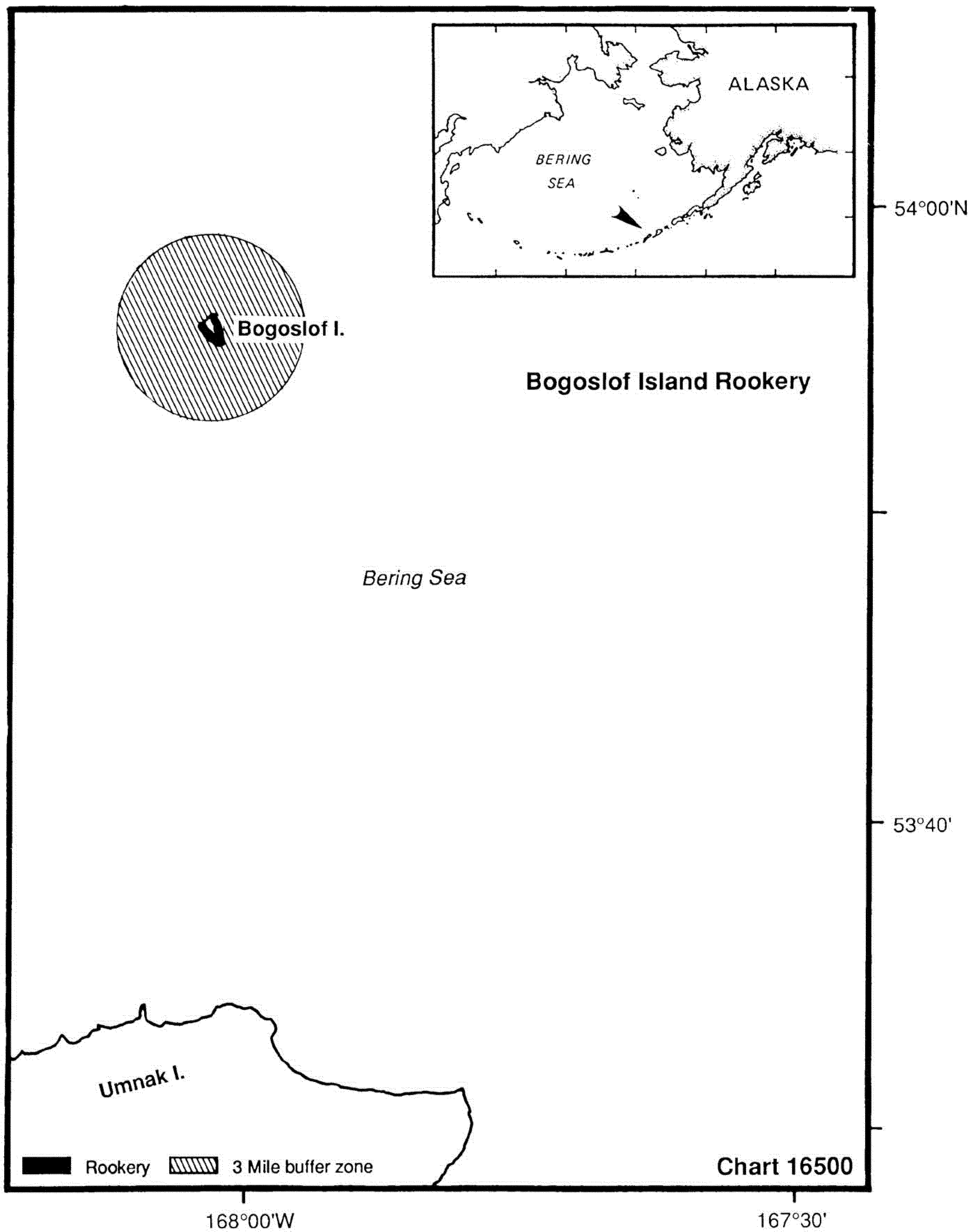
(A) No owner or operator of a vessel may allow the vessel to approach within 3 nautical miles (5.5 kilometers) of a Steller sea lion rookery site listed in paragraph (d)(1)(iii) of this section;
(B) No person may approach on land not privately owned within one-half statutory mile (0.8 kilometers) or within sight of a Steller sea lion rookery site listed in paragraph (d)(1)(iii) of this section, whichever is greater, except on Marmot Island; and
(C) No person may approach on land not privately owned within one and one-half statutory miles (2.4 kilometers) or within sight of the eastern shore of Marmot Island, including the Steller sea lion rookery site listed in paragraph (d)(1)(iii) of this section, whichever is greater.
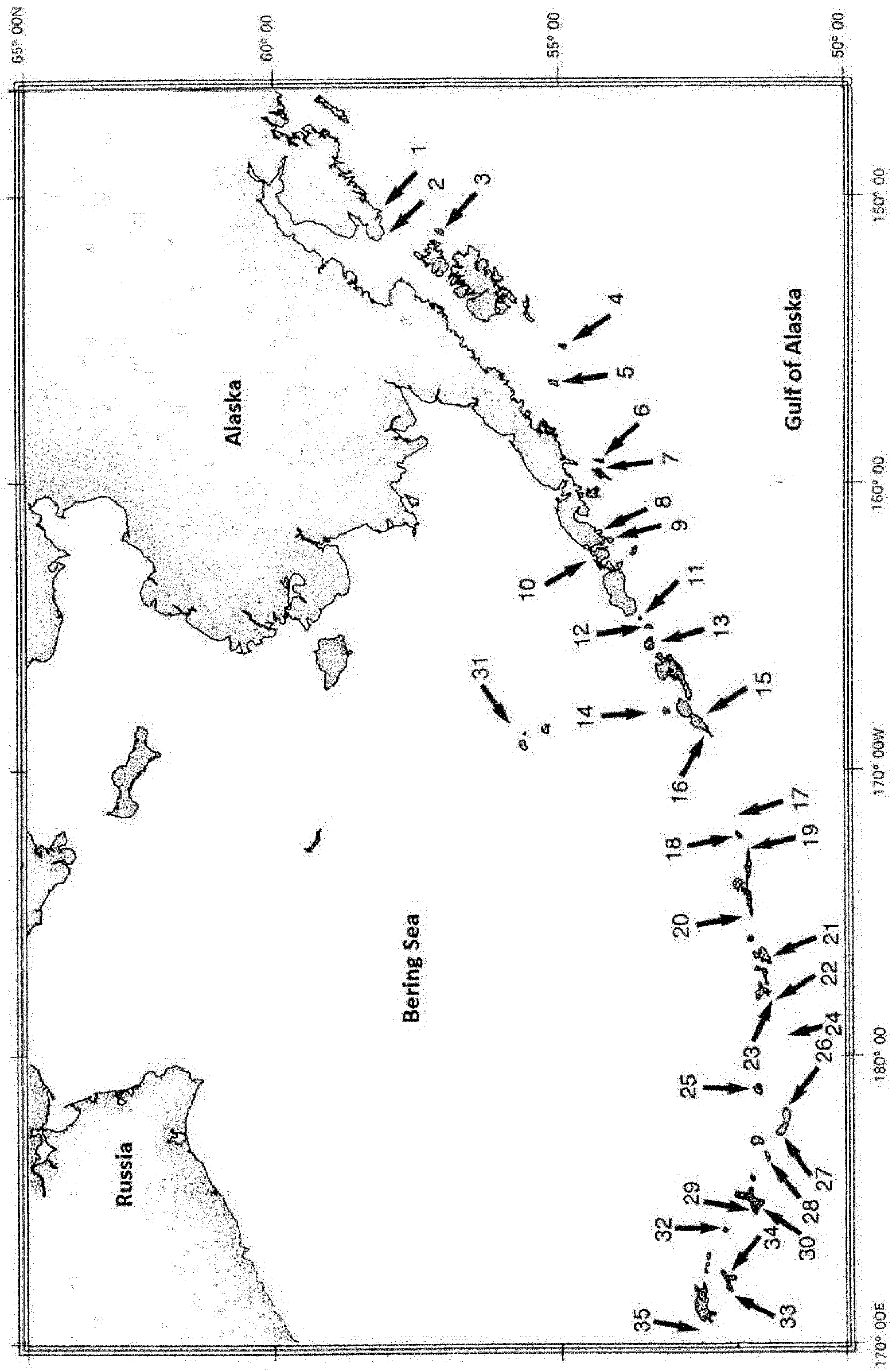
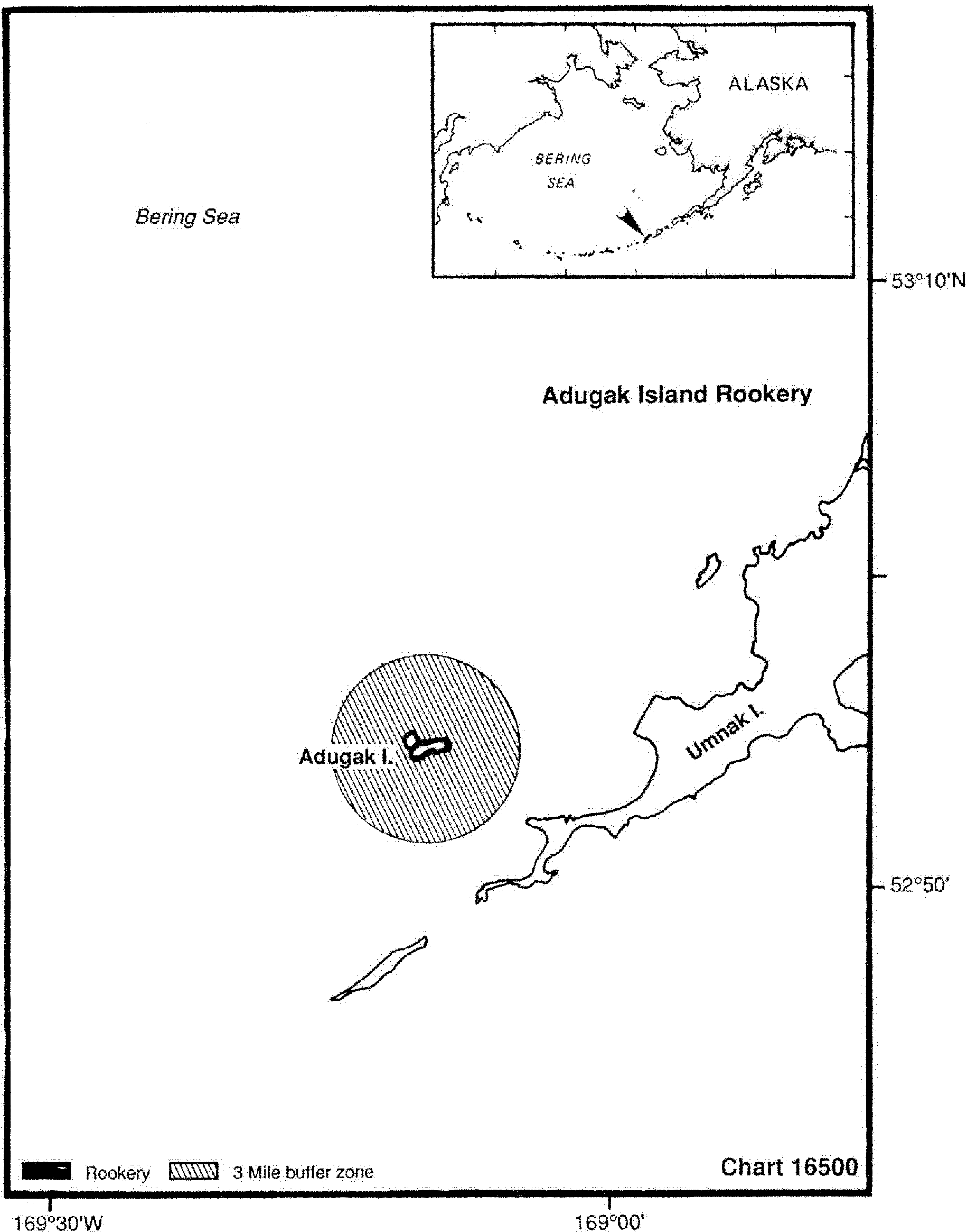
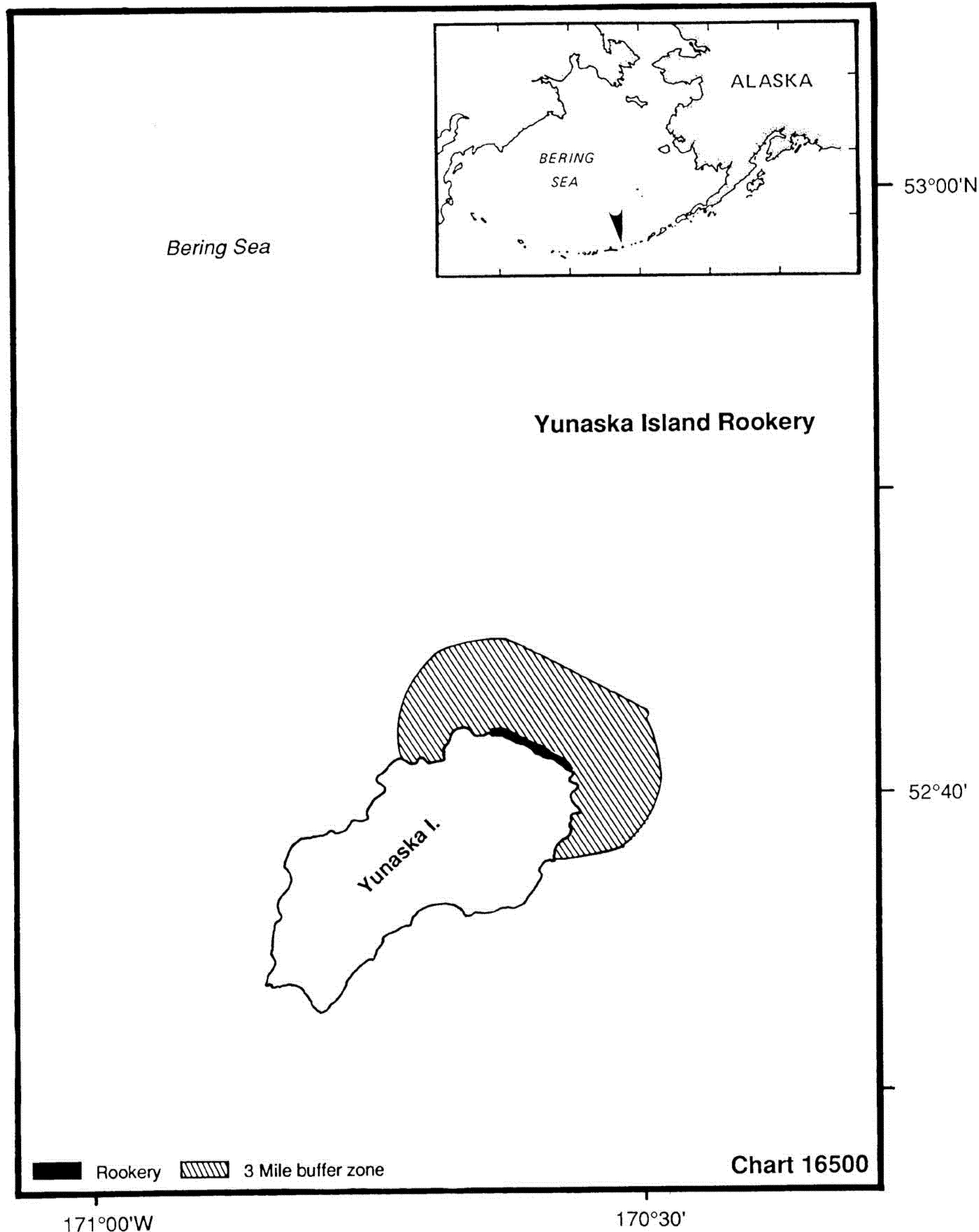
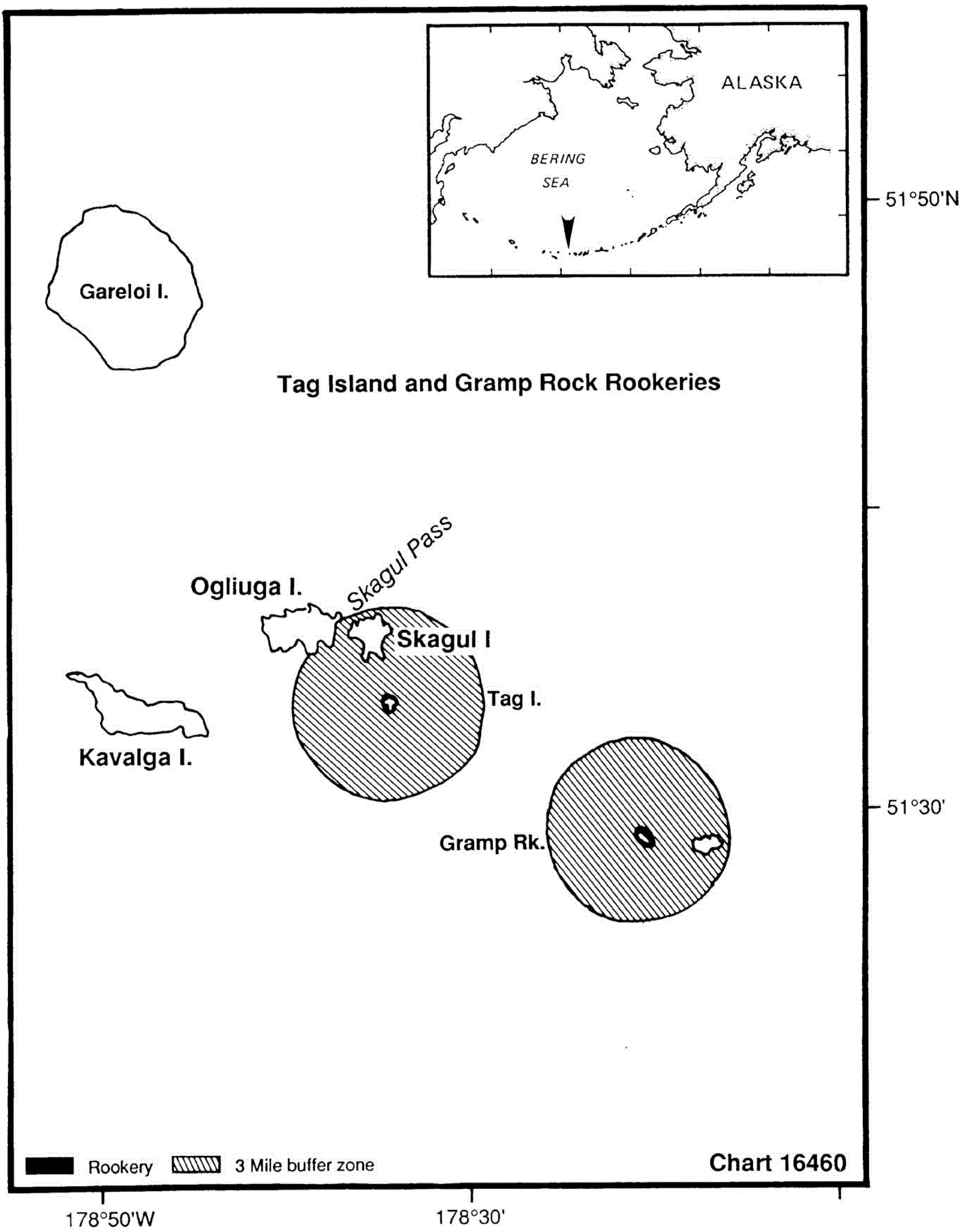
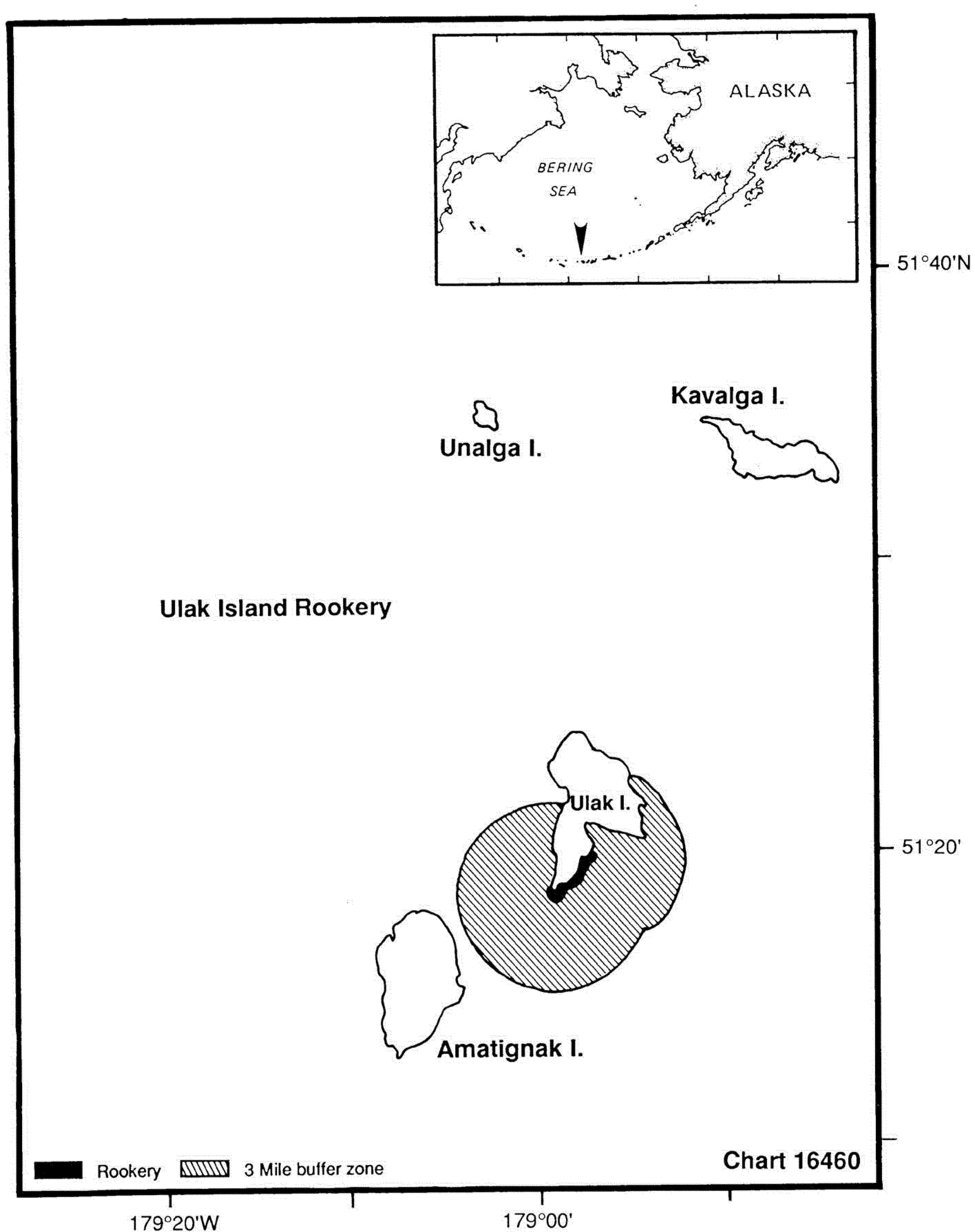
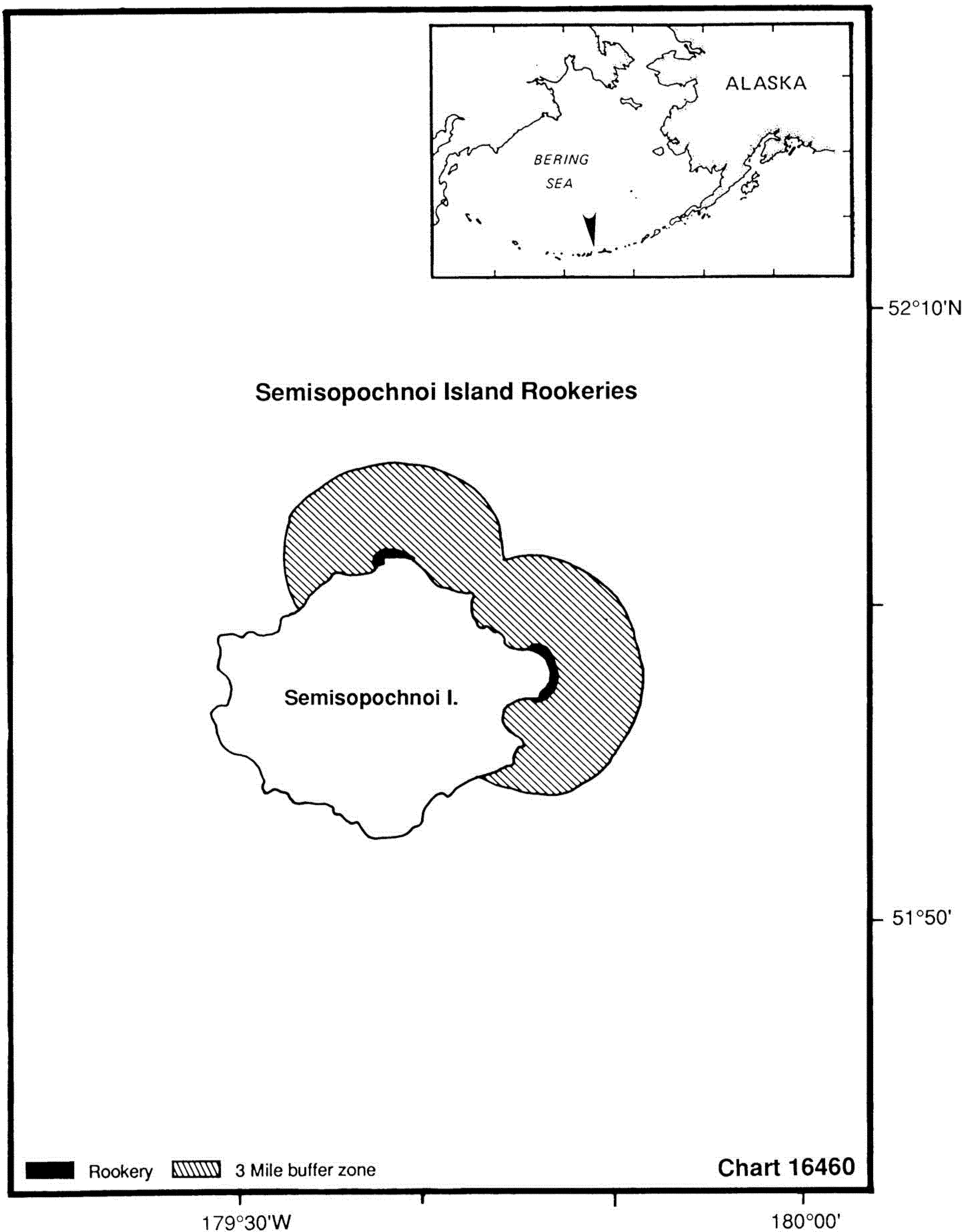
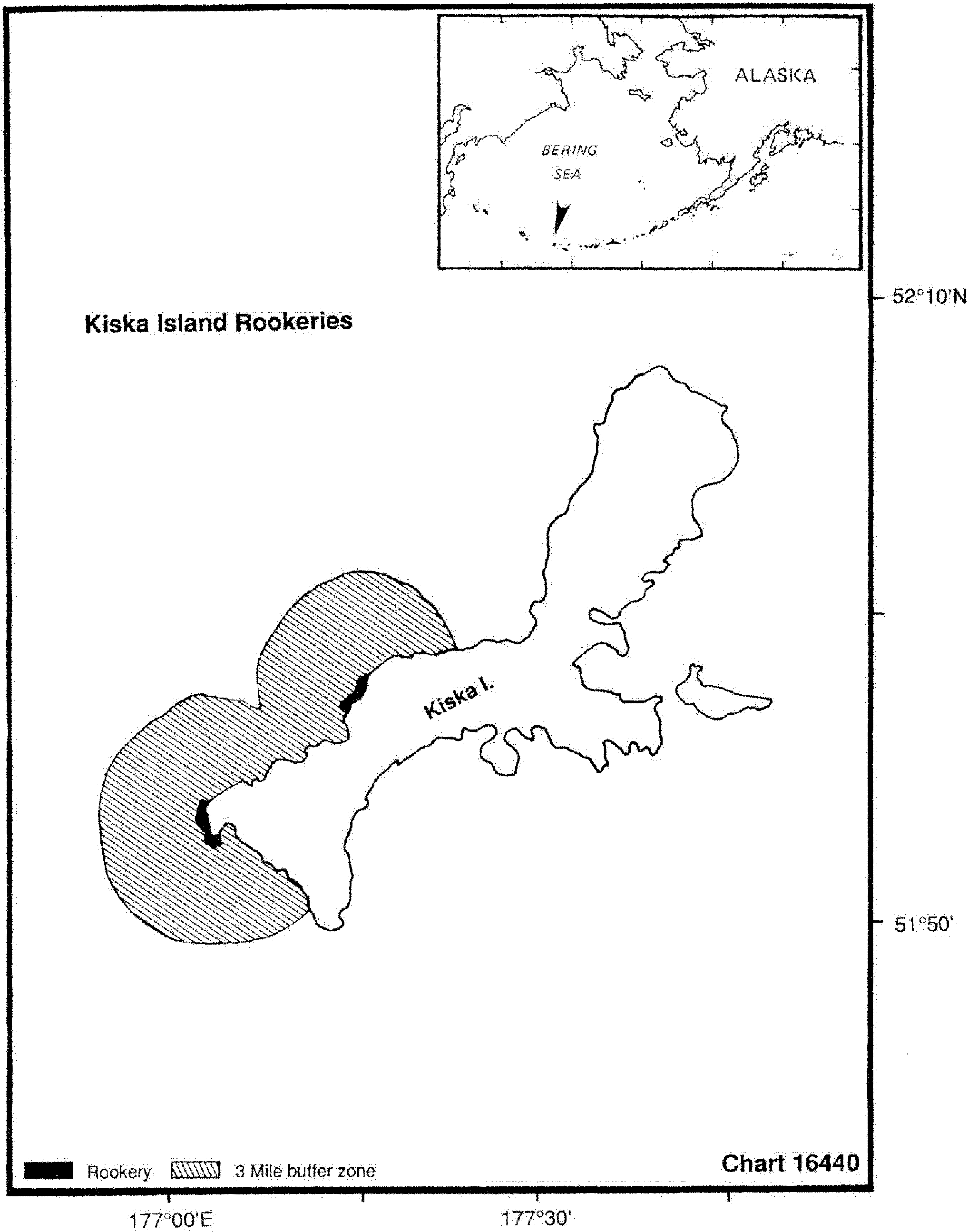
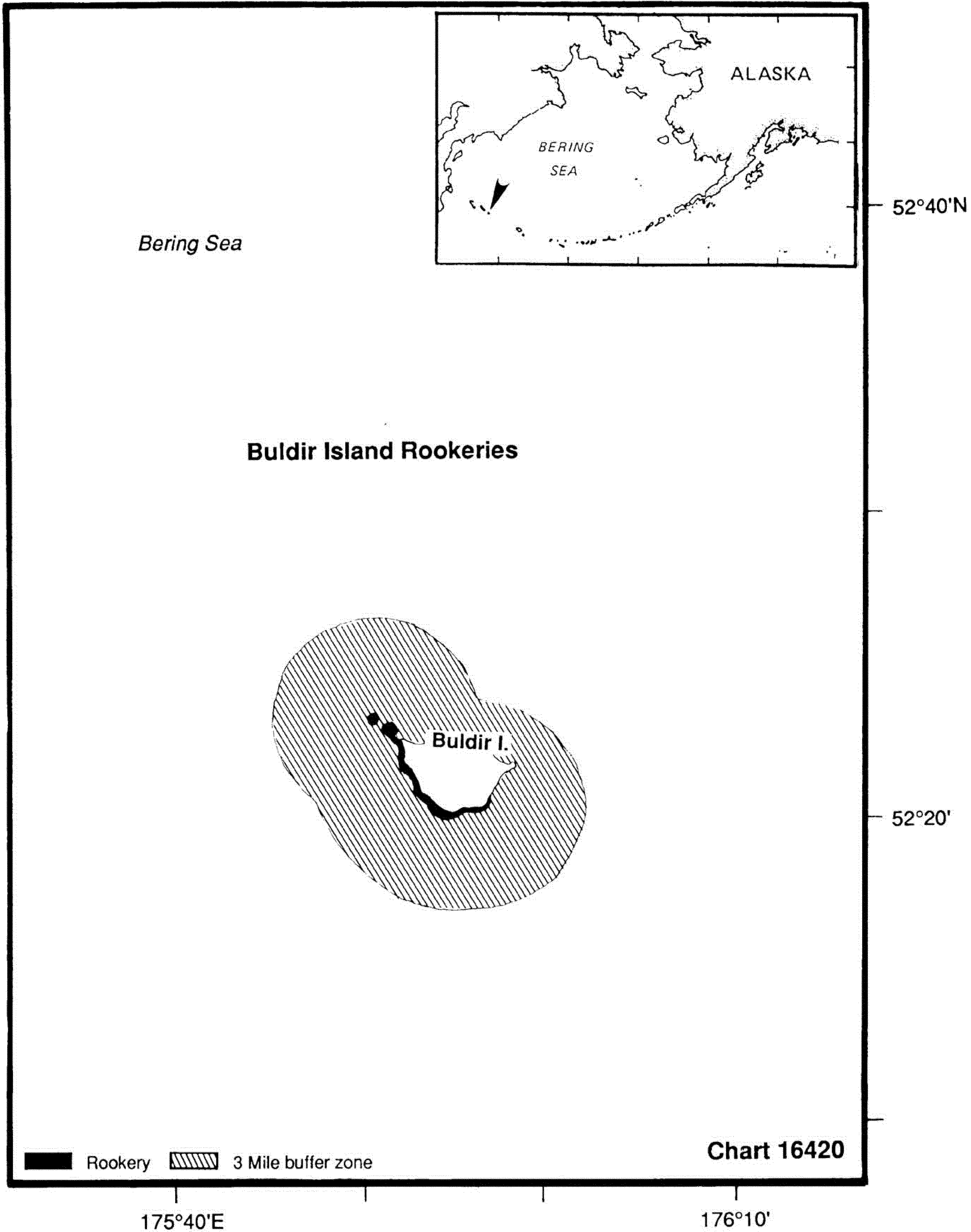
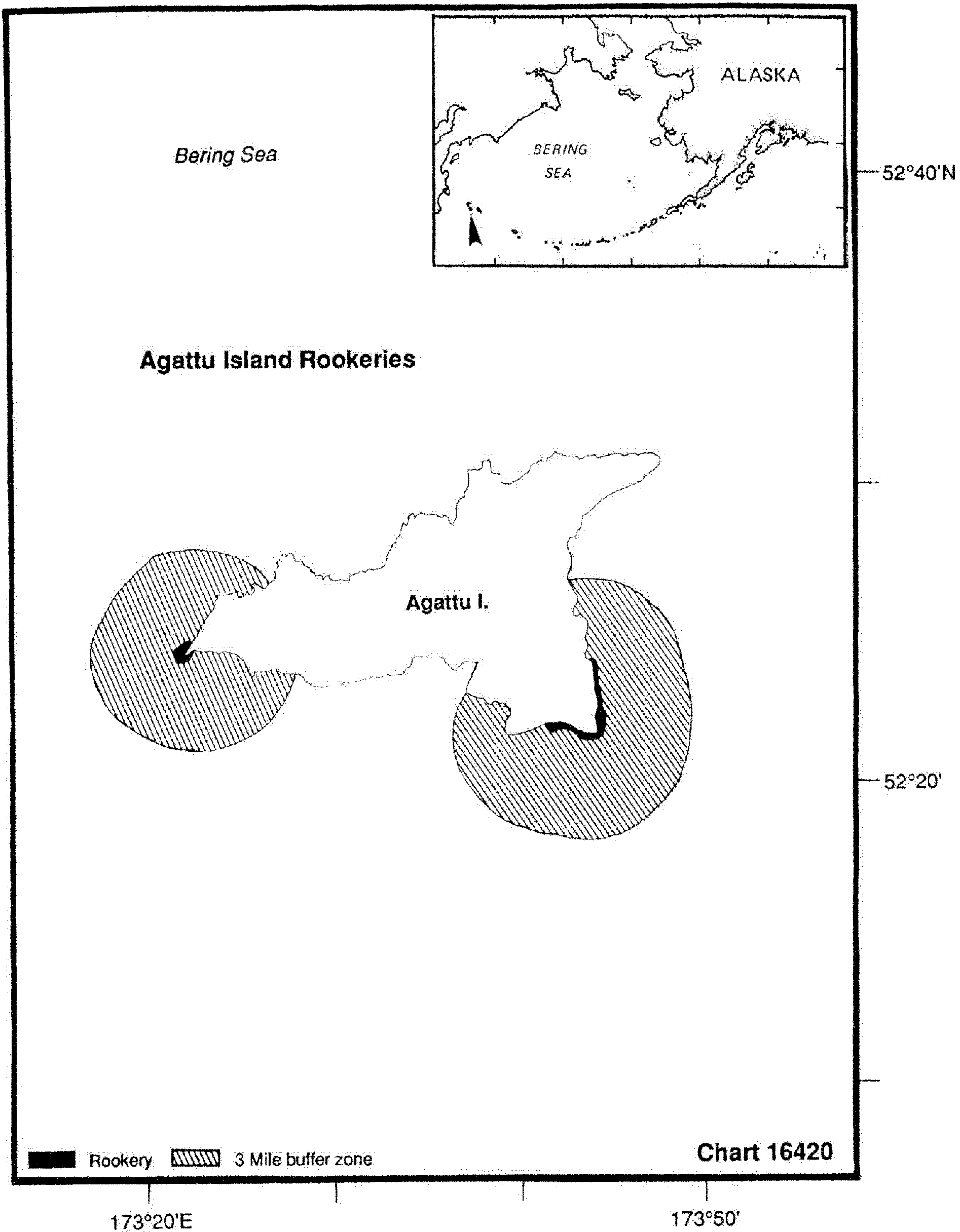
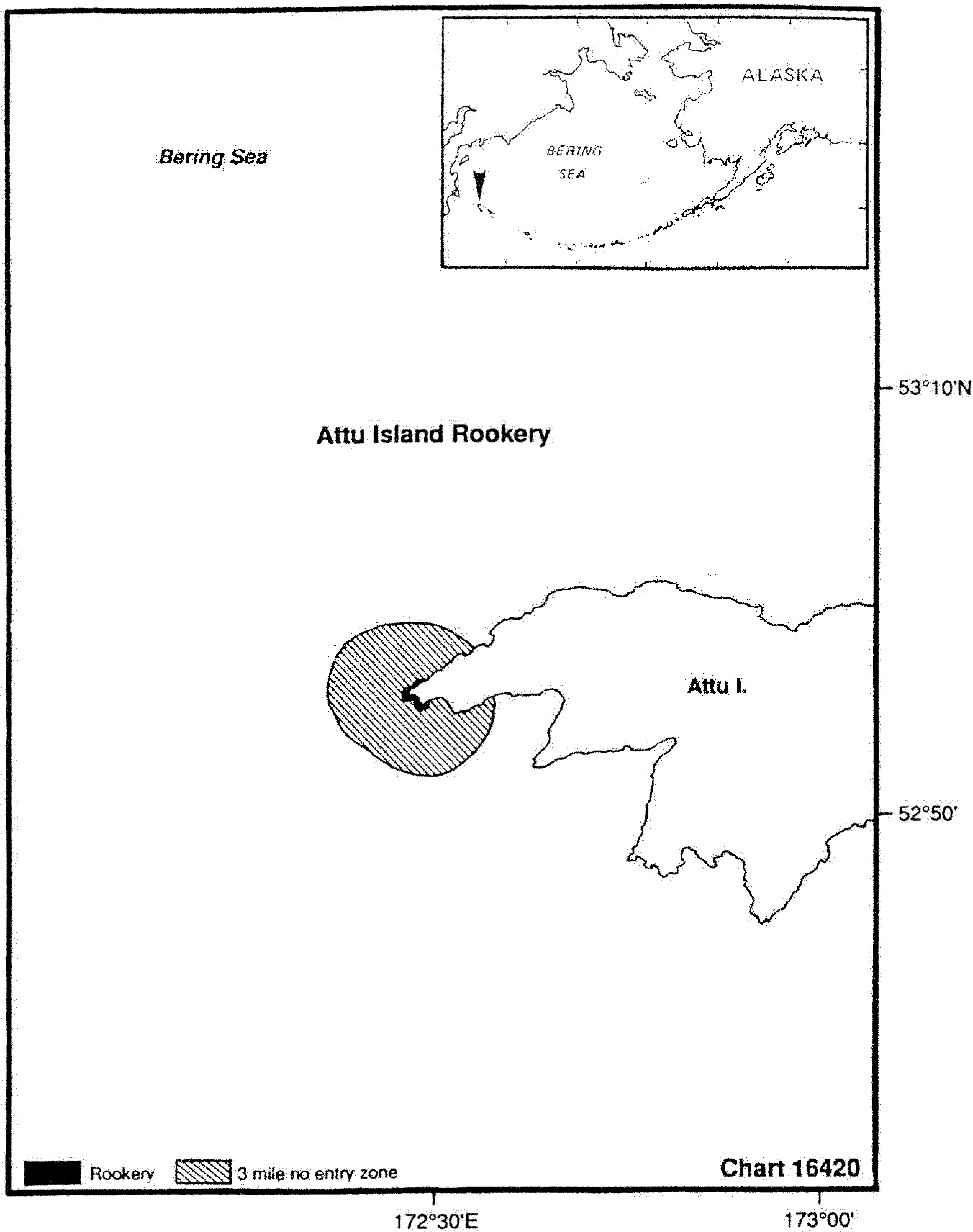
(iii) Listed sea lion rookery sites. Listed Steller sea lion rookery sites consist of the rookeries in the Aleutian Islands and the Gulf of Alaska listed in Table 1.
Table 1 to § 224.103—Listed Steller Sea Lion Rookery Sites1
| Island | From | To | NOAA
Chart |
Notes | ||
|---|---|---|---|---|---|---|
| Lat. | Long. | Lat. | Long. | |||
| 1. Outer I. | 59°20.5 N | 150°23.0 W | 59°21.0 N | 150°24.5 W | 16681 | S quadrant. |
| 2. Sugarloaf I. | 58°53.0 N | 152°02.0 W | 16580 | Whole island. | ||
| 3. Marmot I. | 58°14.5 N | 151°47.5 W | 58°10.0 N | 151°51.0 W | 16580 | SE quadrant. |
| 4. Chirikof I. | 55°46.5 N | 155°39.5 W | 55°46.5 N | 155°43.0 W | 16580 | S quadrant. |
| 5. Chowiet I. | 56°00.5 N | 156°41.5 W | 56°00.5 N | 156°42.0 W | 16013 | S quadrant. |
| 6. Atkins I. | 55°03.5 N | 159°18.5 W | 16540 | Whole island. | ||
| 7. Chernabura I. | 54°47.5 N | 159°31.0 W | 54°45.5 N | 159°33.5 W | 16540 | SE corner. |
| 8. Pinnacle Rock | 54°46.0 N | 161°46.0 W | 16540 | Whole island. | ||
| 9. Clubbing Rks (N) | 54°43.0 N | 162°26.5 W | 16540 | Whole island. | ||
| Clubbing Rks (S) | 54°42.0 N | 162°26.5 W | 16540 | Whole Island. | ||
| 10. Sea Lion Rks | 55°28.0 N | 163°12.0 W | 16520 | Whole island. | ||
| 11. Ugamak I. | 54°14.0 N | 164°48.0 W | 54°13.0 N | 164°48.0 W | 16520 | E end of island. |
| 12. Akun I. | 54°18.0 N | 165°32.5 W | 54°18.0 N | 165°31.5 W | 16547 | Billings Head Bight. |
| 13. Akutan I. | 54°03.5 N | 166°00.0 W | 54°05.5 N | 166°05.0 W | 16520 | SW corner, Cape Morgan. |
| 14. Bogoslof I. | 53°56.0 N | 168°02.0 W | 16500 | Whole island. | ||
| 15. Ogchul I. | 53°00.0 N | 168°24.0 W | 16500 | Whole island. | ||
| 16. Adugak I. | 52°55.0 N | 169°10.5 W | 16500 | Whole island. | ||
| 17. Yunaska I. | 52°42.0 N | 170°38.5 W | 52°41.0 N | 170°34.5 W | 16500 | NE end. |
| 18. Seguam I. | 52°21.0 N | 172°35.0 W | 52°21.0 N | 172°33.0 W | 16480 | N coast, Saddleridge Pt. |
| 19. Agligadak I. | 52°06.5 N | 172°54.0 W | 16480 | Whole island. | ||
| 20. Kasatochi I. | 52°10.0 N | 175°31.5 W | 52°10.5 N | 175°29.0 W | 16480 | N half of island. |
| 21. Adak I. | 51°36.5 N | 176°59.0 W | 51°38.0 N | 176°59.5 W | 16460 | SW Point, Lake Point. |
| 22. Gramp rock | 51°29.0 N | 178°20.5 W | 16460 | Whole island. | ||
| 23. Tag I. | 51°33.5 N | 178°34.5 W | 16460 | Whole island. | ||
| 24. Ulak I. | 51°20.0 N | 178°57.0 W | 51°18.5 N | 178°59.5 W | 16460 | SE corner, Hasgox Pt. |
| 25. Semisopochnoi | 51°58.5 N | 179°45.5 E | 51°57.0 N | 179°46.0 E | 16440 | E quadrant, Pochnoi Pt. |
| Semisopochnoi | 52°01.5 N | 179°37.5 E | 52°01.5 N | 179°39.0 E | 16440 | N quadrant, Petrel Pt. |
| 26. Amchitka I. | 51°22.5 N | 179°28.0 E | 51°21.5 N | 179°25.0 E | 16440 | East Cape. |
| 27. Amchitka I. | 51°32.5 N | 178°49.5 E | 16440 | Column Rocks. | ||
| 28. Ayugadak Pt. | 51°45.5 N | 178°24.5 E | 16440 | SE coast of Rat Island. | ||
| 29. Kiska I. | 51°57.5 N | 177°21.0 E | 51°56.5 N | 177°20.0 E | 16440 | W central, Lief Cove. |
| 30. Kiska I. | 51°52.5 N | 177°13.0 E | 51°53.5 N | 177°12.0 E | 16440 | Cape St. Stephen. |
| 31. Walrus I. | 57°11.0 N | 169°56.0 W | 16380 | Whole island. | ||
| 32. Buldir I. | 52°20.5 N | 175°57.0 E | 52°23.5 N | 175°51.0 E | 16420 | Se point to NW point. |
| 33. Agattu I. | 52°24.0 N | 173°21.5 E | 16420 | Gillion Point. | ||
| 34. Agattu I. | 52°23.5 N | 173°43.5 E | 52°22.0 N | 173°41.0 E | 16420 | Cape Sabak. |
| 35. Attu I. | 52°54.5 N | 172°28.5 E | 52°57.5 N | 172°31.5 E | 16681 | S Quadrant. |


(iv) Commercial Fishing Operations. The incidental mortality and serious injury of endangered Steller sea lions in commercial fisheries can be authorized in compliance with sections 101(a)(5) and 118 of the Marine Mammal Protection Act.
(2) Exceptions —
(i) Permits. The Assistant Administrator may issue permits authorizing activities that would otherwise be prohibited under paragraph (d)(1) of this section in accordance with and subject to the provisions of part 222, subpart C of this chapter—General Permit Procedures.
(ii) Official activities. The taking of Steller sea lions must be reported within 30 days to the Regional Administrator, Alaska Region. Paragraph (d)(1) of this section does not prohibit or restrict a Federal, state or local government official, or his or her designee, who is acting in the course of official duties from:
(A) Taking a Steller sea lion in a humane manner, if the taking is for the protection or welfare of the animal, the protection of the public health and welfare, or the nonlethal removal of nuisance animals; or
(B) Entering the buffer areas to perform activities that are necessary for national defense, or the performance of other legitimate governmental activities.
(iii) Subsistence takings by Alaska natives. Paragraph (d)(1) of this section does not apply to the taking of Steller sea lions for subsistence purposes under section 10(e) of the Act.
(iv) Emergency situations. Paragraph (d)(1)(ii) of this section does not apply to an emergency situation in which compliance with that provision presents a threat to the health, safety, or life of a person or presents a significant threat to the vessel or property.
(v) Exemptions. Paragraph (d)(1)(ii) of this section does not apply to any activity authorized by a prior written exemption from the Regional Administrator, Alaska Region, National Marine Fisheries Service. Concurrently with the issuance of any exemption, the Assistant Administrator will publish notice of the exemption in the Federal Register. An exemption may be granted only if the activity will not have a significant adverse effect on Steller sea lions, the activity has been conducted historically or traditionally in the buffer zones, and there is no readily available and acceptable alternative to or site for the activity.
(vi) Navigational transit. Paragraph (d)(1)(ii) of this section does not prohibit a vessel in transit from passing through a strait, narrows, or passageway listed in this paragraph if the vessel proceeds in continuous transit and maintains a minimum of 1 nautical mile from the rookery site. The listing of a strait, narrows, or passageway does not indicate that the area is safe for navigation. The listed straits, narrows, or passageways include the following:
| Rookery | Straits, narrow, or pass |
|---|---|
| Akutan Island | Akutan Pass between Cape Morgan and Unalga Island. |
| Clubbing Rocks | Between Clubbing Rocks and Cherni Island. |
| Outer Island | Wildcat Pass between Rabbit and Ragged Islands. |
(3) Penalties.
(i) Any person who violates this section or the Act is subject to the penalties specified in section 11 of the Act, and any other penalties provided by law.
(ii) Any vessel used in violation of this subsection or the Endangered Species Act is subject to forfeiture under section 11(e)(4)(B) of the Act.
(e) Protective regulations for killer whales in Washington —
(1) Applicability. The following restrictions apply to all motorized and non-motorized vessels in inland waters of the United States east of a line connecting Cape Flattery, Washington (48°23′10″ N./124°43′32″ W.), Tatoosh Island, Washington (48°23′30″ N./124°44′12″ W.), and Bonilla Point, British Columbia (48°35′30″ N./124°43′00″ W.) and south of the U.S./Canada international boundary. The shoreline boundary is the charted mean high water line cutting across the mouths of all rivers and streams.
(2) Prohibitions. Except as provided in paragraph (e)(3) of this section, it is unlawful for any person subject to the jurisdiction of the United States to:
(i) Cause a vessel to approach, in any manner, within 200 yards (182.9 m) of any killer whale.
(ii) Position a vessel to be in the path of any killer whale at any point located within 400 yards (365.8 m) of the whale. This includes intercepting a killer whale by positioning a vessel so that the prevailing wind or water current carries the vessel into the path of the whale.
(3) Exceptions. The following exceptions apply to this section:
(i) The prohibitions of paragraph (e)(2) of this section do not apply to
(A) Federal Government vessels operating in the course of their official duty or state and local government vessels when engaged in official duties involving law enforcement, search and rescue, or public safety.
(B) Vessels participating with a Vessel Traffic Service (VTS) and following a Traffic Separation Scheme or complying with a VTS Measure of Direction. This also includes support vessels escorting ships in the traffic lanes, such as tug boats.
(C) Vessels engaged in an activity, such as scientific research, authorized through a permit issued by the National Marine Fisheries Service under part 222, subpart C, of this chapter (General Permit Procedures) or through a similar National Marine Fisheries Service authorization.
(D) Vessels lawfully engaged in commercial or treaty Indian fishing that are actively setting, retrieving, or closely tending fishing gear.
(E) Vessel operations necessary to avoid an imminent and serious threat to a person, vessel or the environment, including when necessary for overall safety of navigation and to comply with the Navigation Rules.
(ii) [Reserved]
(4) Affirmative defense. In connection with any action alleging a violation of the prohibitions of paragraph (e)(2) of this section, any person claiming the benefit of any exception listed in paragraph (e)(3) of this section has the burden of raising, pleading, and proving such affirmative defense.
(b) [Reserved]
[64 FR 14066, Mar. 23, 1999, as amended at 66 FR 29509, May 31, 2001; 69 FR 69537, Nov. 30, 2004; 70 FR 1832, Jan. 11, 2005; 76 FR 20890, Apr. 14, 2011; 78 FR 66169, Nov. 4, 2013; 81 FR 62021, 62320, Sept. 8, 2016]
§ 224.104 Special requirements for fishing activities to protect endangered sea turtles.
(a) Shrimp fishermen in the southeastern United States and the Gulf of Mexico who comply with rules for threatened sea turtles specified in § 223.206 of this chapter will not be subject to civil penalties under the Act for incidental captures of endangered sea turtles by shrimp trawl gear.
(b) Summer flounder fishermen in the Summer flounder fishery-sea turtle protection area who comply with rules for threatened sea turtles specified in § 223.206 of this chapter will not be subject to civil penalties under the Act for incidental captures of endangered sea turtles by summer flounder gear.
(c) Special prohibitions relating to sea turtles are provided at § 223.206(d).
[64 FR 14066, Mar. 23, 1999, as amended at 66 FR 44552, Aug. 24, 2001; 66 FR 67496, Dec. 31, 2001; 68 FR 8471, Feb. 21, 2003; 69 FR 18453, Apr. 7, 2004; 72 FR 31757, June 8, 2007]
§ 224.105 Speed restrictions to protect North Atlantic Right Whales.
(a) The following restrictions apply to: All vessels greater than or equal to 65 ft (19.8 m) in overall length and subject to the jurisdiction of the United States, and all other vessels greater than or equal to 65 ft (19.8 m) in overall length entering or departing a port or place subject to the jurisdiction of the United States. These restrictions shall not apply to U.S. vessels owned or operated by, or under contract to, the Federal Government. This exemption extends to foreign sovereign vessels when they are engaging in joint exercises with the U.S. Department of the Navy. In addition, these restrictions do not apply to law enforcement vessels of a State, or political subdivision thereof, when engaged in law enforcement or search and rescue duties.
(1) Southeast U.S. (south of St. Augustine, FL to north of Brunswick, GA): Vessels shall travel at a speed of 10 knots or less over ground during the period of November 15 to April 15 each year in the area bounded by the following: Beginning at 31°27′00.0″ N-080°51′36.0″ W; thence west to charted mean high water line then south along charted mean high water line and inshore limits of COLREGS limit to a latitude of 29°45′00.0″ N thence east to 29°45′00.0″ N-080°51′36.0″ W; thence back to starting point. (Fig. 1).
(2) Mid-Atlantic U.S. (from north of Brunswick, Georgia to Rhode Island): Vessels shall travel 10 knots or less over ground in the period November 1 to April 30 each year:
(i) In the area bounded by the following: 33°56′42.0″ N-077°31′30.0″ W; thence along a NW bearing of 313.26° True to charted mean high water line then south along mean high water line and inshore limits of COLREGS limit to a latitude of 31°27′00.0″ N; thence east to 31°27′00.0″ N-080°51′36.0″ W; thence to 31°50′00.0″ N-080°33′12.0″ W; thence to 32°59′06.0″ N-078°50′18.0″ W; thence to 33°28′24.0″ N-078°32′30.0″ W; thence to 33°36′30.0″ N-077°47′06.0″ W; thence back to starting point.;
(ii) Within a 20-nm (37 km) radius (as measured seaward from COLREGS delineated coast lines and the center point of the port entrance) (Fig. 2) at the
(A) Ports of New York/New Jersey: 40°29′42.2″ N-073°55′57.6″ W;
(B) Delaware Bay (Ports of Philadelphia and Wilmington): 38°52′27.4″ N-075°01′32.1″ W;
(C) Entrance to the Chesapeake Bay (Ports of Hampton Roads and Baltimore): 37°00′36.9″ N-075°57′50.5″ W; and
(D) Ports of Morehead City and Beaufort, NC: 34°41′32.0″ N-076°40′08.3″ W; and
(iii) In Block Island Sound, in the area bounded by the following coordinates: Beginning at 40°51′53.7″ N-70°36′44.9″ W; thence to 41°20′14.1″ N-70°49′44.1″ W; thence to 41°04′16.7″ N-71°51′21.0″ W; thence to 40°35′56.5″ N-71°38′25.1″ W; thence back to starting point. (Fig. 2).
(3) Northeast U.S. (north of Rhode Island):
(i) In Cape Cod Bay, MA: Vessels shall travel at a speed of 10 knots or less over ground during the period of January 1 to May 15 in Cape Cod Bay, in an area beginning at 42°04′56.5″ N-070°12′00.0″ W; thence north to 42°12′00.0″ N-070°12′00.0″ W; thence due west to charted mean high water line; thence along charted mean high water within Cape Cod Bay back to beginning point. (Fig. 3).
(ii) Off Race Point: Vessels shall travel at a speed of 10 knots or less over ground during the period of March 1 to April 30 each year in waters bounded by straight lines connecting the following points in the order stated (Fig. 3): 42°30′00.0″ N-069°45′00.0″ W; thence to 42°30′00.0″ N-070°30′00.0″ W; thence to 42°12′00.0″ N-070°30′00.0″ W; thence to 42°12′00.0″ N-070°12′00.0″ W; thence to 42°04′56.5″ N-070°12′00.0″ W; thence along charted mean high water line and inshore limits of COLREGS limit to a latitude of 41°40′00.0″ N; thence due east to 41°41′00.0″ N-069°45′00.0″ W; thence back to starting point.
(iii) Great South Channel: Vessels shall travel at a speed of 10 knots or less over ground during the period of April 1 to July 31 each year in all waters bounded by straight lines connecting the following points in the order stated (Fig. 3):
42°30′00.0″ N-069°45′00.0″ W
41°40′00.0″ N-069°45′00.0″ W
41°00′00.0″ N-069°05′00.0″ W
42°09′00.0″ N-067°08′24.0″ W
42°30′00.0″ N-067°27′00.0″ W
42°30′00.0″ N-069°45′00.0″ W
(b) Except as noted in paragraph (c) of this section, it is unlawful under this section:
(1) For any vessel subject to the jurisdiction of the United States to violate any speed restriction established in paragraph (a) of this section; or
(2) For any vessel entering or departing a port or place under the jurisdiction of the United States to violate any speed restriction established in paragraph (a) of this section.
(c) A vessel may operate at a speed necessary to maintain safe maneuvering speed instead of the required ten knots only if justified because the vessel is in an area where oceanographic, hydrographic and/or meteorological conditions severely restrict the maneuverability of the vessel and the need to operate at such speed is confirmed by the pilot on board or, when a vessel is not carrying a pilot, the master of the vessel. If a deviation from the ten-knot speed limit is necessary, the reasons for the deviation, the speed at which the vessel is operated, the latitude and longitude of the area, and the time and duration of such deviation shall be entered into the logbook of the vessel. The master of the vessel shall attest to the accuracy of the logbook entry by signing and dating it.
(d) No later than January 1, 2019, the National Marine Fisheries Service will publish and seek comment on a report evaluating the conservation value and economic and navigational safety impacts of this section, including any recommendations to minimize burden of such impacts.
[79 FR 34245, June 16, 2014]